Was gonna make a Brexit joke, but then I realized the UK is also still in Europe.
You are using an out of date browser. It may not display this or other websites correctly.
You should upgrade or use an alternative browser.
You should upgrade or use an alternative browser.
Return of Horrible Educational Maps
- Thread starter Westphalian
- Start date
BrcloneWas gonna make a Brexit joke, but then I realized the UK is also still in Europe.
Gotta appreciate the Greek Albania, Austrian Slovenia, Russian Lithuania, Nordic Union, and Belarus-Ukraine. 👍
Russian Lithuania
Latvia actually.
Not to forget the nation of the Black Sea.
Ah right, I said the wrong thing.Latvia actually.
Not to forget the nation of the Black Sea.
The Black Sea Republic shows up so many times in these things that it doesn't even phase me anymore lol
*sad Serb noises*Oh, and Bosnia finally can into long coastline!
Once again, not for education. It’s a ball-ish pillow with a map date that I can’t quite put my finger on… Looks all the world like “just after Czechoslovakian collapse” except for the independent Ukraine.
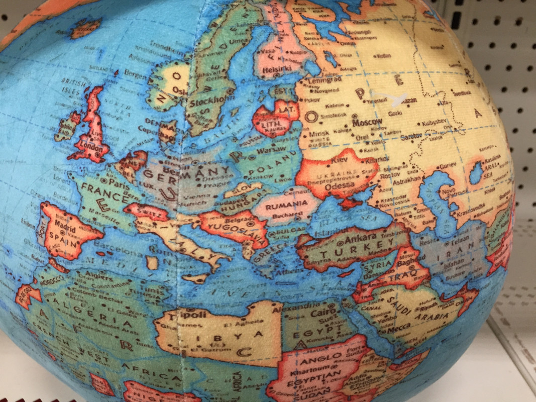
Looks like Nazi Germany is still extant....Once again, not for education. It’s a ball-ish pillow with a map date that I can’t quite put my finger on… Looks all the world like “just after Czechoslovakian collapse” except for the independent Ukraine.
It looks like pre-WW2, but after Germany's annexation of Czechia and Austria. So late 1930s? Because you have French West Africa and Anglo-Egyptian Sudan in there.. Also "Trans-Jordan" and "Leningrad."Once again, not for education. It’s a ball-ish pillow with a map date that I can’t quite put my finger on… Looks all the world like “just after Czechoslovakian collapse” except for the independent Ukraine.
Independent Ukraine is the thing that doesn't fit the late 30s time period?
It looks like pre-WW2, but after Germany's annexation of Czechia and Austria. So late 1930s? Because you have French West Africa and Anglo-Egyptian Sudan in there.. Also "Trans-Jordan" and "Leningrad."
Independent Ukraine is the thing that doesn't fit the late 30s time period?
Maybe the map maker refused to accept that the briefly independent Ukraine after WWI had ceased to exist.
Anyways, have a display from the Pyongyang Science Museum:
My bigger question is who is making pillow balls maps of the late 1930s?Once again, not for education. It’s a ball-ish pillow with a map date that I can’t quite put my finger on… Looks all the world like “just after Czechoslovakian collapse” except for the independent Ukraine.
Good ol’ Dome Earth Theory.Maybe the map maker refused to accept that the briefly independent Ukraine after WWI had ceased to exist.
Anyways, have a display from the Pyongyang Science Museum:
View attachment 906361
Michael’s, apparently.My bigger question is who is making pillow balls maps of the late 1930s?
I don't think Ukraine is independent on the map, despite the awkward color difference with the rest of the USSROnce again, not for education. It’s a ball-ish pillow with a map date that I can’t quite put my finger on… Looks all the world like “just after Czechoslovakian collapse” except for the independent Ukraine.
- No capital marker
- The font for "Ukraine" is completely different than other nations
- No dash-dot line separating Ukraine with the USSR
I don't think Ukraine is independent on the map, despite the awkward color difference with the rest of the USSR
- No capital marker
- The font for "Ukraine" is completely different than other nations
- No dash-dot line separating Ukraine with the USSR
Was Ukraine perhaps added later on this map?
Inclusion of Crimea also points in that direction since Crimea was Russian until 1954.
Maybe, but I doubt it. This 1924 map also incorrectly shows various Soviet polities as separate, with Crimea as well.Was Ukraine perhaps added later on this map?
Inclusion of Crimea also points in that direction since Crimea was Russian until 1954.
Austrian Hungary and reunified Ireland?
I worked at Michaels up until recently, and I remember seeing this ✨aesthetic✨ wall sign in store and being quietly horrified that they'd used a map with Africa carved up and the Congo Free State visible at center:Michael’s, apparently.
Also of interest is this "map banner" depicting North America somewhere between 1898 and 1905 (note the old districts of the NWT in the Canadian prairies):
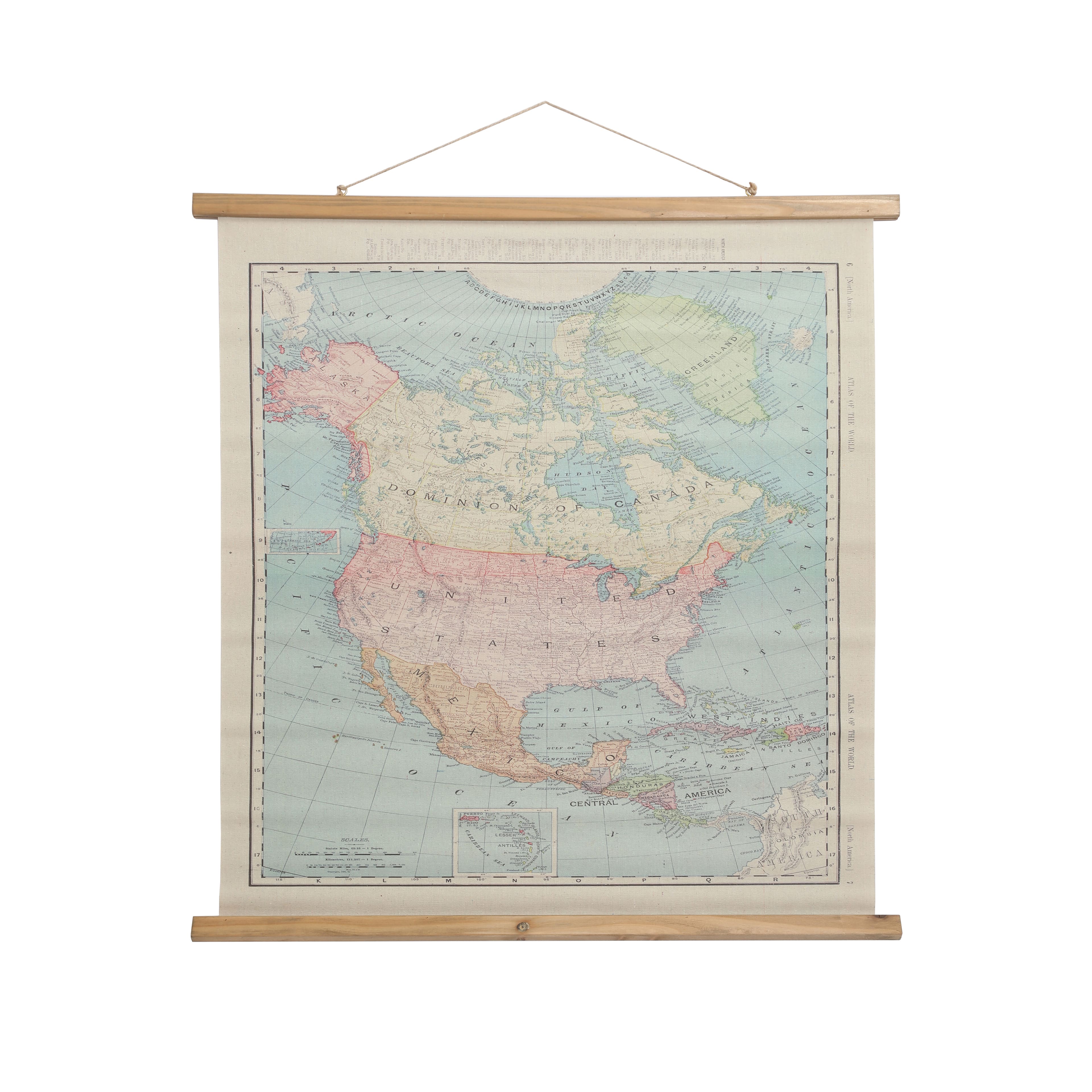
But prominently depicting Nazi Germany on a product... Is it too much to ask for any historical literacy at all from their design team?
Last edited:
Share: