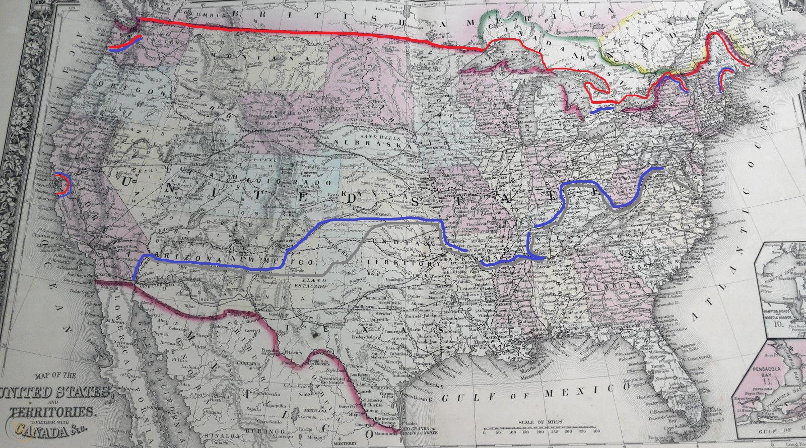
Not really per say, but because I want to try and portray the changes in the lines here's a very very rough map which shows the 'front's as it were by July 1863
Blue is the Union
Red is the British
Grey is the Confederacy
The rough outline for the Northern Front is that the British control a swathe of the interior of Maine (save Bangor) and a chunk of Maine on the border protecting the Temiscouta Road which controls their overland communications. Facing them are Keye's Army of New England, two divisions strong, largely blocking Portland and a few independent units of Maine Volunteers, 4,000 at Bangor and company strength along the frontier who are basically on their own.
Further inland, the British have invaded New York and are besieging Ticonderoga with the Army of Canada under Dundas. Opposing them is the much battered Army of the Hudson under Burnside.
The Upper Canada Field Force (3rd Corps Army of Canada) is facing the Army of Niagara outside Toronto, both sides are essentially stalled as the campaign in Western Canada is a sideshow.
The red along the borders shows that the British broadly control the pre-war border as far as the Pacific Northwest where landings by a strong brigade of regulars have taken control of Portland in Washington Territory and by extension the entire Olympic Peninsula.
Meanwhile, a division sized British force controls San Francisco and the surrounding environs while the Americans are cordoning them off but operating from the state capital at Sacramento.
Going from west to east on with the Union and the Confederates:
As I hope you can see, the Confederates broadly control what they're calling Arizona territory, running along the thirty-fourth parallel while the Union forces in the north control the territory there. This is largely tenuous as each side is also fighting a side war against the various Indigenous tribes in the region. The Apaches the most ferocious. The big bump you see in the lines is where the word Comanche appears on the map. The Comancheria is, for all intents and purposes, a separate power between the two groups and they've driven the line of settlement near them for over 100 miles in each direction.
Beyond that, the Confederates control the Indian Territory, but crossing into Arkansas the two sides are broadly facing each other along the banks of the Arkansas River. Crossing the Mississippi you'll see that the Union armies are besieging Grenada and Corinth, while they effectively only control Tennessee on the western banks of the Tennessee River and above Nashville. The Confederates hold East Tennessee and Kentucky below the Salt River and to Frankfort very securely. The lines then meander onwards, the Union controlling what OTL becomes West Virginia, while meanwhile Lee is around Washington besieging the army of the Potomac under McClellan, and beyond that Thomas is gathering an army to hopefully break the siege.
Very rough and tumble, but that's about where things stand by July 1863.